
 Sale!
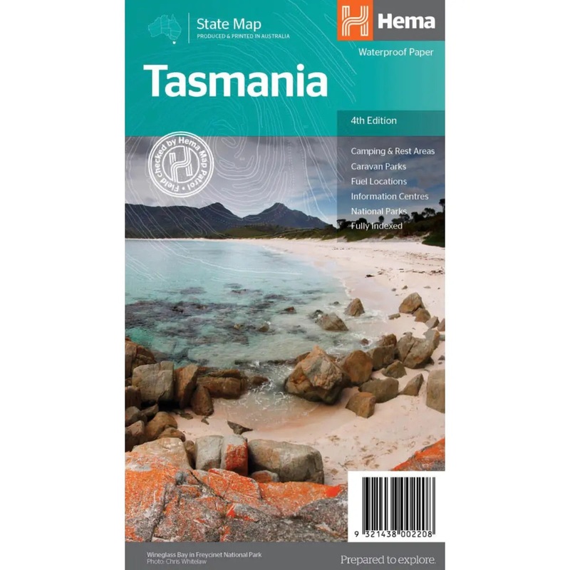
Sale! Hema Tasmania State Map – 4th Edition
A fully indexed state map of Tasmania at a scale of 1:500,000. Marked on the mapping are national parks, 24-hour fuel as well as camping and rest areas. On the reverse are detailed maps of the Zeehan and Region (including Lake St Clair and Franklin-Gordon
$9.99
-
$7.99
 100% Happiness Backed or Your Money Back
- Spend 30, Ship Free
- Love It or Return It Within 60 Days
Details
A fully indexed state map of Tasmania at a scale of 1:500,000. Marked on the mapping are national parks, 24-hour fuel as well as camping and rest areas. On the reverse are detailed maps of the Zeehan and Region (including Lake St Clair and Franklin-Gordon Rivers National Park), Freycinet National Park, Southwest National Park and Hobart & Region Complete list of Tasmanian Visitor Information Centres.
The reverse side consists of:
- A summary of the key things to see and do broken up into the North West, Launceston, Tamar and the North
- A table listing of National Parks and Reserves with key features and facilities (such as Camping and Caravan sites, BBQ, toilets and showers)
- Visitor centre listing
- Map of the area around Zeehan and Queenstown at 1:250,000 scale (including Lake St Claire and Franklin-Gordon Rivers National Parks)
- Map of Freycinet National Park at 1:125,000 scale
- Map of Southwest National Park at 1:200,000 scale
- Map of Hobart & Region at 1:250,000 scale (including petrol stations, information centres and rest stops marked)
Tasmania is located off the southeast corner of mainland Australia. It is Australia’s smallest state in terms of both size and population, yet is a major tourist attraction due to the diverse and spectacular scenery, unspoilt wilderness, fantastic food and wine and heritage and cultural sites.
Key Features:
- Fully updated and indexed primary Map of Tasmania at a scale of 1:500,000 and showing national parks, fuel locations as well as campsites and caravan parks
- Detailed maps of the Zeehan and Region (including Lake St Clair and Franklin-Gordon Rivers National Park), Freycinet National Park, Southwest National Park and Hobart & Region
- Complete list of Tasmanian Visitor Information Centres
- Table showing Tasmanias National Parks and Reserves with key features and facilities
- Summary of the key things to see in Tasmania broken up by region
Shipping Info
- Cost: $25
- Free Shipping
- We offer free shipping on orders over $30. Please check the free - shipping eligibility at checkout.
- Delivery Time:
- It usually takes [3-5] business days for standard shipping. Please note that this is an estimated time frame and may be affected by local holidays, and unforeseen circumstances.
Related products


Reviews
There are no reviews yet.